Flooding: Understanding, preparing and mitigating risk and damage

Heavier-than-usual rain events and larger and longer storm events are becoming more common in Australia and around the world, whether due to the impact of climate change on existing weather patterns or the result of natural phenomena, such as La Niña or El Niño. The discipline of engineering has a mandate to respond, with planning for these events becoming the norm for responsible design. It is imperative that designs are well considered and free from inadequate planning and engineering design, so as to reduce risk and mitigate the effects of flooding, which can have devastating economic and social consequences.

A flood can damage your home, belongings and livelihood. It can disrupt your electricity and water supply. It can make roads and bridges impassable. And it can put your health and safety at risk. That is why it is so important to be prepared for a flood before it happens.

There is no way of preventing flooding entirely. But risk management strategies can help limit your exposure to the potential devastation of this type of natural disaster. At JN, we believe that responsible development and considered engineering design are crucial in mitigating the risk of flooding and best preparing for its impact on life and property.

It’s important that homeowners and businesses understand the risks associated with flooding and implement appropriate measures to protect against potential losses, while government bodies proactively form strategies and policies that aim to minimise the effects of flooding on the community. In this article, we’ll explore what flood risk is, how it’s assessed, and some of the measures that can be taken to mitigate its impact.

Key Flood Terminology

  • Flood Impact Assessment (FIA): An FIA is an appraisal of a proposed development against local council’s flood planning policies and controls, and is a requirement for Development Applications in known flood-risk areas. Key assessment areas often include minimum floor levels and ensuring the proposed development does not impact the nature of flooding surrounding the site.
  • Annual Exceedance Probability (AEP): The AEP is a statistical measure of the likelihood of a flood of a certain magnitude occurring in any given year. The AEP is important for flood risk management and is used to assess the probability and frequency of floods in a particular area, which helps in the design of flood protection measures and in the development of flood warning systems. A 1% AEP means a 1-in-100 chance that a flood of that size will occur in any one year, and is the equivalent of the older, but still used Average Recurrence Interval (ARI) measure of “1 in 100 year” flood.
  • Probable Maximum Flood (PMF): The PMF refers to the theoretical maximum flood that could occur in a particular area under extreme weather conditions. PMF is an important factor in designing infrastructure such as dams, bridges and buildings in flood-prone areas.
  • Flood Modelling (TUFLOW & HEC-RAS models): Flood modelling is used to help understand the flood risk to a site. TUFLOW and HEC-RAS are flood simulation software that use survey and terrain data to provide a base for a flood model. Catchments and flows are calculated and then run over the terrain models. HEC-RAS modelling is utilised for one-dimensional flood flows (within a contained channel or similar, where water does not leave the channel and flows in one linear direction), whereas TUFLOW modelling is utilised for two-dimensional flood flows, which may occur within roads, properties, parks and streams that occur in more than one linear direction. This information is used to determine the Flood Planning Levels (FPLs) and provide input into Flood Evacuation Management Plans (FEMPs).
  • Flood Planning Levels (FPL): FPLs assist in determining a safe design level for ground floors for developments within flood-prone areas. FPLs ensure that the habitable or living spaces of a development are flood-free and remain safe for occupants and end users. FPLs are set above the flood level, and generally include a safety factor known as “freeboard” – the minimum height of the lowest habitable level of the building. Freeboard is specified by local councils in their flooding documentation, based on assessment by specialists in flooding engineering.
  • Flood Evacuation Management Plans (FEMP): FEMPs are documents which provide details relating to site-specific safety measures, processes and procedures that ensure the safety of the end user of a flood affected building. Additionally, FEMPs outline the systems and processes that should be in place prior to the occurrence of any flooding, and what actions should be undertaken to ensure that these processes are regularly maintained and functional in preparation of a flood event. FEMPs also provide a map that outlines the safest route away from the site in the occurrence of a flood, and the contact details for local emergency services should a flood occur. FEMPs are critical to developments within flood effected areas and serve as a potential life saving measure.

What is Flood Risk and how is it assessed?

Flood Risk is a measure that combines the likelihood that a given area will experience flooding and the nature of flooding likely to occur. Flooding can occur due to several different factors, including heavy rainfall, storm events, tidal surges and dam or levee failure. When assessing flood risk, planners consider both the probability of a flooding event occurring and the expected damage if one were to occur.

To understand your site’s flood risk, you can apply for a flood information certificate from your local council. If no information is available, engineers like JN can complete flood modelling to determine a site-specific flood level for your property.

Measures to Mitigate the Risk and Impact of Floods

Fortunately, there are several different measures that can be taken to mitigate the risk and impact of flooding. These measures can be broadly grouped into four categories: land use planning, insurance, physical mitigation and crisis-planning measures:

  • Land use planning measures involve changing the way land is used. For example, planning for development in areas that are less likely to flood or requiring new buildings to be constructed above the flood level. Unfortunately, if these considerations aren’t addressed in initial planning, they prove a significant challenge in flood-proofing susceptible areas, and often require micro-level solutions to minimise risk to individual properties.

  • Insurance measures involve transferring the financial risk of floods to an insurance company. This can help protect you from the financial devastation caused by flooding. Flood insurance covers the cost of repairs or replacement up to the limits of your policy. It can also cover the cost of temporary housing if your home is uninhabitable due to flooding. Flood insurance is not necessarily covered by standard homeowners’ insurance policies, so be sure to talk to your insurance agent about getting a tailored policy. Insurance, while recommended, does not do anything to minimise most of the practical inconveniences caused by significant flooding, or addresses its often profound psychological and emotional impact.

  • Physical mitigation measures on a macro level involve constructing physical barriers (levees or dams) or expanding existing ones, such as widening river channels. These measures are expensive and unfortunately not always effective. Physical mitigation measures can, however, be undertaken at a site-specific level, to help offset the risk to a specific property, appreciating its particular geographical, topographical and climatic characteristics.

  • Crisis-planning measures provide ready procedures for what to do before, during and after a flood crisis takes hold. They should include things like putting together an emergency kit, identifying evacuation routes and knowing where to go if you must evacuate. If you have pets, be sure to include them in your plan – they will need food and shelter too!

Being prepared for a flood can help minimise the damage caused by flooding and make recovery easier. By understanding your risk, getting insured, seeking and acting on professional advice and making a crisis plan ahead of time, you’ll be better prepared for whatever Mother Nature throws your way.

How can JN help?

JN appreciates that every site is different. Our flood mitigation services rely on thorough case-by-case analysis and understanding, so site-specific solutions can be developed with our expertise and the best available engineering technologies.

JN is highly experienced in developing flood modelling to determine flood affectation for development sites. We have expert capability in using state of the art flood modelling software (TUFLOW and HEC-RAS).

We provide Flood Planning Levels (FPL) for developments within predetermined flood zones. JN assists in determining freeboard levels for our clients, either based on available flooding data supplied by council via an existing flood model or by creating a flood model using HEC-RAS or TUFLOW. Once the flood level is determined, JN can then add a freeboard and determine the FPL for the design.

JN is highly experienced in the development of FEMPs and associated works and can assist in reviewing and updating current FEMPs, or re-assessing FEMPs to ensure all information is relevant, up to date and compliant with regulations.

If you are planning a new build, renovation or are simply interested in ensuring your property is safe from flooding, your first step is to get in touch with your local council to find out if you are located in a flood affected area. If council confirms that your property is susceptible to flooding, we welcome you to get in touch with one of our expert Civil Engineers at JN to help.

Here are some case studies that showcase JN’s capabilities in assessing and minimising flood risk:

Flood Modelling| Galbraith Street, Quakers Hill
Client: Belle Property Strathfield
JN was engaged by Belle Property Group to undertake a flood and stormwater assessment of a development site at Galbraith Street, Quakers Hill. The investigation required the assessment of the existing flood conditions and the affectation of the development on the surrounding area. JN assessed the existing stormwater system as well as the catchments to determine the flows, and then modelled the existing and development flood extents using TUFLOW modelling software. The findings were used in the submission to Council for assessment.

Flood Study | Industrial Units – 318 Horsley Road, Milperra
Client: The Walsh Group
JN was engaged by The Walsh Group to undertake a flood and stormwater assessment of the development site at 318 Horsley Road, Milperra. The investigation required the assessment of the existing flood conditions and the affectation of the development on the surrounding area. The developable site lies within the Milperra industrial zone, which is regularly inundated due to flooding, overland flow and tailwater effects due to the George’s River and Chipping Norton Lake. JN assessed the existing stormwater system as well as the catchments to determine the flows, and then modelled the existing and development flood extents using TUFLOW modelling software. The findings were used in the submission to Council for assessment.

Civil, Structural and Flood Study | Carnes Hill Recreation and Community Precinct
Client: Liverpool City Council Architect: DWP Suters

JN were responsible for the Civil and Structural documentation of the $30 million dollar Carnes Hill Recreation and Community Precinct. The Civil Engineering component addressed the roads, car parking, rigid and flexible pavement designs, stormwater drainage, raingarden basins, WSUD swales, external footpath pavement slabs, pedestrian crossings, slip lanes, intersections, line marking and signage, bulk earthworks and a Flood Study. JN determined the flood levels and flood extents for various storm events. Habitable buildings required floor levels to be set with 0.5m freeboard above the 1% AEP level (1 in 100 year ARI) and the lower access roads and carparking needed to be set at or above the 5% AEP level (1 in 20 year ARI). The Structural Engineering work included the design of buildings and retaining walls. The precinct was designed to support the ongoing demands for much needed social, cultural and recreational facilities for the local community. Stretching across a 70,000 square metre site, the centre consists of a gym, library, public plaza with a water feature and public art, a skate park, children’s playground, outdoor multipurpose sports courts, community centre, picnic area, a cafe, cycling and walking paths as well as parking facilities.

Flood Modelling | Oaks Airfield
Client: Stephen Bennett

JN was engaged by Stephen Bennett to undertake a flood model to facilitate the proposed redevelopment of The Oaks Aerodrome. The site bounds Werriberri Creek and sits at the confluence of this with other minor local streams. A significant portion of the existing site is located below the 1% AEP flood level and this constrains the type and nature of permissible development. Raising the site levels by filling across the flood storage areas would alleviate this problem but would also risk negatively impacting other adjacent properties which is not compliant with authority regulations or good engineering design. Hence, JN identified the key risks areas where flood impacts would occur and suggested strategies such as offset storage areas to alleviate these whilst still allowing for the site to be raised.

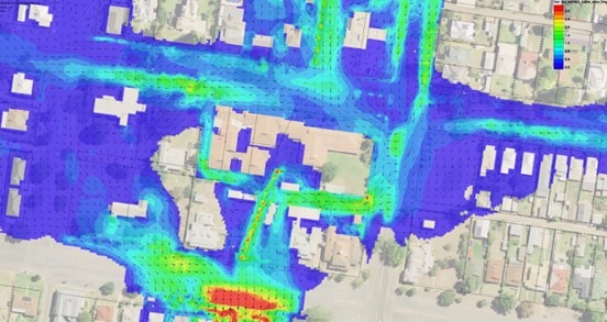
Flood Modelling and Project Management | Aged Care
Client: RSL LifeCare

JN was engaged after a section of the existing aged care building flooded in March 2022, with up to 0.5m depth of flood waters running through the building, necessitating the evacuation of its elderly residents. Our client’s insurance company covered this event, however our client was instructed to implement measures to prevent subsequent flooding in future flood events in order to remain insured. JN carried out TUFLOW modelling to determine the worst case 1% AEP flood event and the results showed that the site could flood to water depths of over 1.0m deep. JN are currently consulting with flood barrier manufacturer specialists to provide temporary flood protection measures around the building. Council have recently announced proposals to upgrade the existing drainage network in the suburb to relieve this site and surrounding sites of similar flooding issues.

Share
Top